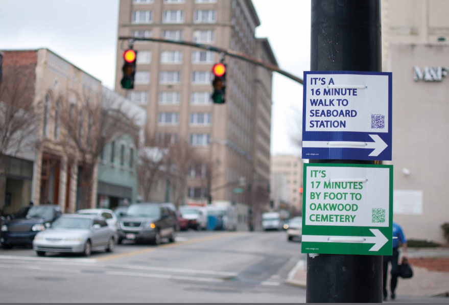
For Matt Tomasulo, the inclination to drive in downtown Raleigh, North Carolina, was a result more of perceived distance than actual necessity – a tendency endemic in many American cities. As an antidote to this misconception, he devised Walk Raleigh, an unsanctioned wayfinding system for pedestrians. Tomasulo hung 27 signs at three major Raleigh intersections, each with a directional arrow, a count of how many “minutes by foot†are necessary to reach a destination, and a QR code for more information. Though the signs were removed within days of being posted, overwhelming support from the local community led the Raleigh City Council to reinstate Walk Raleigh as an official pilot project, promoting a healthier and safer pedestrian environment in the city.
- Projects
- 61st Street Farmers Market
- 78th Street Play Street
- 596 Acres
- 1415
- ACTIVATE!
- Air Quality Egg
- AirCasting
- Amphibious Architecture
- Aquaponics Container System
- Art in Odd Places
- ARTfarm
- Astoria Scum River Bridge
- Bartering and Sharing Networks
- Bat Cloud
- Bench Press
- Better Block
- BK Farmyards
- Brooklyn Night Bazaar
- Bubbleware
- Building Projections
- Bunchy Carter Park for the People
- By the City/For the City
- Campito
- Cart Coop
- chainlinkGREEN
- Chair-bombing
- Chicago Rarities Orchard Project
- City Farm
- The City from the Valley
- City Sensing: Signal Spaces
- Cleveland Bridge Project
- Come Out & Play Festival
- Community Living Room
- Crown Heights Participatory Urbanism
- Cut.Join.Play.
- Day Labor Station
- Depave
- Dérive App
- Detroit, Demolition, Disneyland
- Dream It. Grow It.
- Eco-Playground
- Edible Estates
- Edible Schoolyard
- Edible Wall
- Faubourg St. Roch Project
- Field Guide to Phytoremediation
- Flint Public Art Project
- For Squat / Reuben Kincaid Realty
- Fresh Moves Mobile Market
- Ghost Bikes
- GOOD Ideas for Cities
- Grassroots Mapping
- Greenaid Seedbomb Vending Machine
- Guerrilla Bike Lanes
- Guerrilla Drive-Ins
- Guerrilla Gardening
- Guerrilla Grafters
- Harvest Dome
- Holding Pattern
- Hypothetical Development Organization
- I Wish This Was
- ICE-POPS
- Iluminacción
- Imagination Playground
- Imaging Detroit
- Insert____Here
- Intersection Repair
- Islands of LA
- Kingshighway Skatepark
- KISS Popup Chapel
- LA Green Grounds
- Legal Waiting Zone
- LentSpace
- LightLane
- Linden Living Alley
- Local Code: Real Estates
- Local Previews
- Making Policy Public
- Marcus Prize Pavilion
- Mobile Dumpster Pools
- Moving Design: Civic Intervention
- Museum of the Phantom City
- MyBlockNYC
- Neighborland
- New Public Sites
- NY Street Advertising Takeover
- No Longer Empty
- Notes for Anyone
- Occupy Wall Street
- OpenPlans
- Paintings for Satellites
- Parking Plot
- Parklets
- Parkman Triangle Park
- Parkmobiles
- Participation Park
- People Make Parks
- Periscope Project
- Phone Booth Book Share
- PHS Pops-Up Garden
- Piazza Gratissima
- Pixelator
- Place It!
- Place Pulse
- Placemaking in Bronzeville
- Pop Up City
- Pop Up Lunch
- Pop-Up Art Loop
- Popularise: Build Your City
- popuphood
- Post Furniture
- Power Cart
- Power House
- proxy
- PUPstop Project
- QR_Hobo_Codes
- Queens Boulevard Intervention
- re:NEWS
- Red Swing Project
- San Francisco Garden Registry
- SeeClickFix
- Serendipitor
- Skipping Only Zones
- Soil Kitchen
- Spatial ConTXTs
- Stairway Stories
- Streetfilms
- Syracuse Downtown
- Tactical Urbanism Handbook
- TrafficCOM
- Ten New Historical Markers
- TERRITORY
- TreeKIT
- Trees, Cabs and Crime in San Francisco
- The Uni
- Version Festival 12
- Visionary Chicago
- Walk Raleigh: Guerrilla Wayfinding
- War Gastronomy: Recipes of Relocation
- #whOWNSpace
- Yarnbombing
- Teams
CityFabric
Walk Raleigh: Guerrilla Wayfinding
Raleigh, North Carolina
2012
Accessibility, Community, Economy, Information, Pleasure, Sustainability
275
1 week – planning & production + 1 hour installation
3
Problem - misperception of travel distances
Solution - simple signs showing travel time by foot
