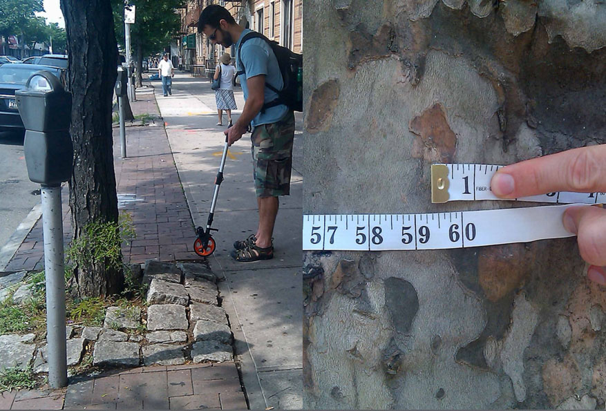
In some cities, dead trees are as numerous as potholes, but get a lot less attention. For this reason, landscape architect Liz Barry and urban forester Philip Silva developed TreeKIT, a system to measure, map, and manage urban forests. Volunteers use simple site-survey- ing skills to map trees in urban areas. TreeKIT’s website features a map showing tree density block by block, and users can zoom in on trees to click for information about trunk dimension, genus, or species. The map also color-codes empty treebeds, stumps, and dead trees. This data is shared with city agencies and local tree steward organizations. Studies indicate healthy trees in urban areas can filter pollutants, reduce heat island effect, reduce CO2, and prevent runoff as well as create safe inviting public spaces.
- Projects
- 61st Street Farmers Market
- 78th Street Play Street
- 596 Acres
- 1415
- ACTIVATE!
- Air Quality Egg
- AirCasting
- Amphibious Architecture
- Aquaponics Container System
- Art in Odd Places
- ARTfarm
- Astoria Scum River Bridge
- Bartering and Sharing Networks
- Bat Cloud
- Bench Press
- Better Block
- BK Farmyards
- Brooklyn Night Bazaar
- Bubbleware
- Building Projections
- Bunchy Carter Park for the People
- By the City/For the City
- Campito
- Cart Coop
- chainlinkGREEN
- Chair-bombing
- Chicago Rarities Orchard Project
- City Farm
- The City from the Valley
- City Sensing: Signal Spaces
- Cleveland Bridge Project
- Come Out & Play Festival
- Community Living Room
- Crown Heights Participatory Urbanism
- Cut.Join.Play.
- Day Labor Station
- Depave
- Dérive App
- Detroit, Demolition, Disneyland
- Dream It. Grow It.
- Eco-Playground
- Edible Estates
- Edible Schoolyard
- Edible Wall
- Faubourg St. Roch Project
- Field Guide to Phytoremediation
- Flint Public Art Project
- For Squat / Reuben Kincaid Realty
- Fresh Moves Mobile Market
- Ghost Bikes
- GOOD Ideas for Cities
- Grassroots Mapping
- Greenaid Seedbomb Vending Machine
- Guerrilla Bike Lanes
- Guerrilla Drive-Ins
- Guerrilla Gardening
- Guerrilla Grafters
- Harvest Dome
- Holding Pattern
- Hypothetical Development Organization
- I Wish This Was
- ICE-POPS
- Iluminacción
- Imagination Playground
- Imaging Detroit
- Insert____Here
- Intersection Repair
- Islands of LA
- Kingshighway Skatepark
- KISS Popup Chapel
- LA Green Grounds
- Legal Waiting Zone
- LentSpace
- LightLane
- Linden Living Alley
- Local Code: Real Estates
- Local Previews
- Making Policy Public
- Marcus Prize Pavilion
- Mobile Dumpster Pools
- Moving Design: Civic Intervention
- Museum of the Phantom City
- MyBlockNYC
- Neighborland
- New Public Sites
- NY Street Advertising Takeover
- No Longer Empty
- Notes for Anyone
- Occupy Wall Street
- OpenPlans
- Paintings for Satellites
- Parking Plot
- Parklets
- Parkman Triangle Park
- Parkmobiles
- Participation Park
- People Make Parks
- Periscope Project
- Phone Booth Book Share
- PHS Pops-Up Garden
- Piazza Gratissima
- Pixelator
- Place It!
- Place Pulse
- Placemaking in Bronzeville
- Pop Up City
- Pop Up Lunch
- Pop-Up Art Loop
- Popularise: Build Your City
- popuphood
- Post Furniture
- Power Cart
- Power House
- proxy
- PUPstop Project
- QR_Hobo_Codes
- Queens Boulevard Intervention
- re:NEWS
- Red Swing Project
- San Francisco Garden Registry
- SeeClickFix
- Serendipitor
- Skipping Only Zones
- Soil Kitchen
- Spatial ConTXTs
- Stairway Stories
- Streetfilms
- Syracuse Downtown
- Tactical Urbanism Handbook
- TrafficCOM
- Ten New Historical Markers
- TERRITORY
- TreeKIT
- Trees, Cabs and Crime in San Francisco
- The Uni
- Version Festival 12
- Visionary Chicago
- Walk Raleigh: Guerrilla Wayfinding
- War Gastronomy: Recipes of Relocation
- #whOWNSpace
- Yarnbombing
- Teams
TreeKIT
TreeKIT
New York City
since 2011
Community, Information, Sustainability
75,000 annual budget
1 1â„2 months – map more than 10,000 trees
150
Problem - urban trees die without coordinated stewardship
Solution - measure, map & manage the urban forest
