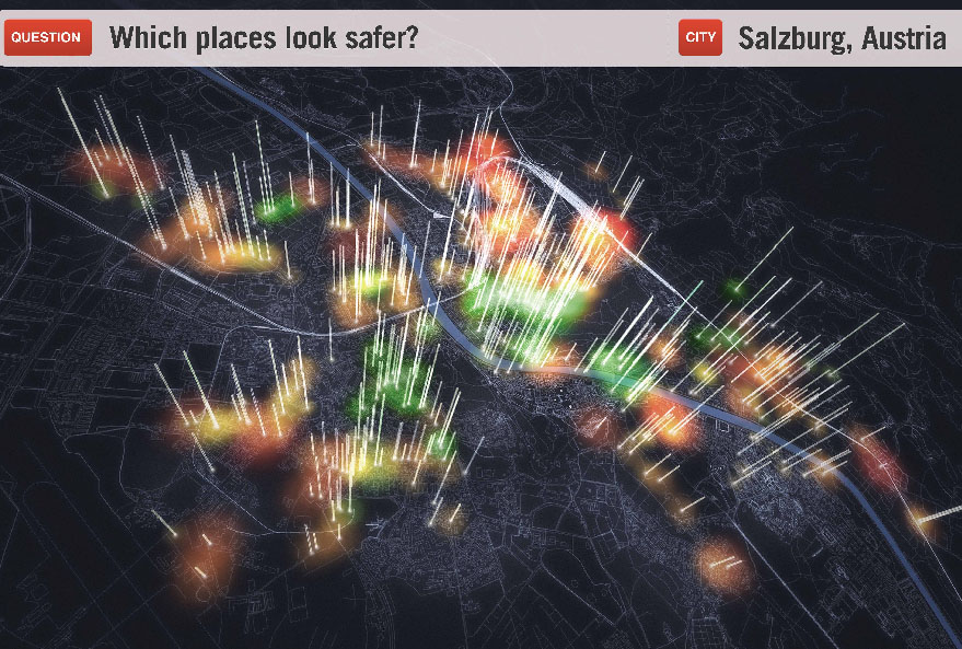
Place Pulse players are shown two side-by-side Google Street View images along with a question (for example, “Which place looks safer?”). Players click on the image of their choice, earning points that can be exchanged for access to additional game features. Over time, Place Pulse converts opinions shared in-game into perception scores for each place, creating a quantitative measure of urban perception. Scores are mapped and used to identify areas that are most in need of improvements. Developed by an MIT Media Lab team led by Phil Salesses, this digital tool is intended to help cities become more flexible and representative of the desires of their inhabitants
- Projects
- 78th Street Play Street
- 596 Acres
- 1415
- Air Quality Egg
- AirCasting
- Amphibious Architecture
- Aquaponics Container System
- Art in Odd Places
- ARTfarm
- Astoria Scum River Bridge
- Bartering and Sharing Networks
- Bat Cloud
- Bench Press
- Better Block
- BK Farmyards
- Brooklyn Night Bazaar
- Bubbleware
- Building Projections
- Bunchy Carter Park for the People
- By the City/For the City
- Campito
- Cart Coop
- chainlinkGREEN
- Chair-bombing
- City Farm
- City Sensing: Signal Spaces
- Come Out & Play Festival
- Community Living Room
- Crown Heights Participatory Urbanism
- Cut.Join.Play.
- Day Labor Station
- Depave
- Dérive App
- Detroit, Demolition, Disneyland
- Eco-Playground
- Edible Estates
- Edible Schoolyard
- Edible Wall
- Faubourg St. Roch Project
- Field Guide to Phytoremediation
- For Squat / Reuben Kincaid Realty
- Fresh Moves Mobile Market
- Ghost Bikes
- GOOD Ideas for Cities
- Grassroots Mapping
- Greenaid Seedbomb Vending Machine
- Guerrilla Bike Lanes
- Guerrilla Drive-Ins
- Guerrilla Gardening
- Guerrilla Grafters
- Harvest Dome
- Hypothetical Development Organization
- I Wish This Was
- ICE-POPS
- Iluminacción
- Imagination Playground
- Insert____Here
- Intersection Repair
- Islands of LA
- Kingshighway Skatepark
- KISS Popup Chapel
- LA Green Grounds
- Legal Waiting Zone
- LentSpace
- LightLane
- Linden Living Alley
- Local Code: Real Estates
- Local Previews
- Making Policy Public
- Marcus Prize Pavilion
- Mobile Dumpster Pools
- Museum of the Phantom City
- MyBlockNYC
- Neighborland
- New Public Sites
- NY Street Advertising Takeover
- No Longer Empty
- Occupy Wall Street
- OpenPlans
- Paintings for Satellites
- Parking Plot
- Parklets
- Parkman Triangle Park
- Parkmobiles
- Participation Park
- People Make Parks
- Periscope Project
- Phone Booth Book Share
- PHS Pops-Up Garden
- Pixelator
- Place It!
- Place Pulse
- Pop Up City
- Pop Up Lunch
- Pop-Up Art Loop
- Popularise: Build Your City
- popuphood
- Post Furniture
- Power Cart
- Power House
- proxy
- QR_Hobo_Codes
- Queens Boulevard Intervention
- re:NEWS
- Red Swing Project
- San Francisco Garden Registry
- SeeClickFix
- Serendipitor
- Skipping Only Zones
- Soil Kitchen
- Spatial ConTXTs
- Stairway Stories
- Streetfilms
- Syracuse Downtown
- Tactical Urbanism Handbook
- Ten New Historical Markers
- TreeKIT
- Trees, Cabs and Crime in San Francisco
- The Uni
- Version Festival 12
- Walk Raleigh: Guerrilla Wayfinding
- War Gastronomy: Recipes of Relocation
- #whOWNSpace
- Yarnbombing
- Teams
MIT Media Lab
Place Pulse
Online
2011 to present
Accessibility, Community, Information, Pleasure
50,000
1,600 hours
10
Problem - difficult to measure perception of urban space
Solution - crowdsource public response with online visual surveys


